Verde River Institute
Verde River Photogrammetry / Mapping
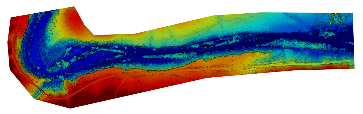
Verde River Elevation Model - SOB Canyon to Sullivan Ranch
The Verde River Institute is currently undertaking a major new project to define the geomorphology and riparian vegetative cover of the Verde River in the Verde Valley. The project will cover the Verde’s reach between the Sycamore Canyon confluence at river mile 36 and will include the river's flood plain through river mile 86 at Beasley Flat. The photogrammetric study will use approximately 8000 aerial images to produce a suite of maps that will provide a valuable baseline dataset of the river. These will include 3D, elevation, and 2D high-resolution imagery of the flood plain for these 50 miles of river. An example of the maps is on-line at: https://tinyurl.com/y9uewcll
We hope to complete the initial photogrammetry while the riparian forest is in full leaf in the fall of 2018 or by late spring 2019. These maps allow us to measure the volume of canopy cover, areas of fields or buildings, "cut and fill" volumes, and other useful measurements. From time to time, we will recreate the maps in other seasons, or ad hoc for reaches that are important to stakeholders, land managers, or the conservation community. These maps will be extremely useful now and in the future.
The images used to create the maps are taken by unmanned aerial vehicles (drones) that fly a preplanned grid over the subject area and then upload the images to a server where they are collated into the various map products.
The overarching goal of this program is to create a baseline dataset that will establish the current condition of the river through the Verde Valley, and to create a set of aerial missions that can be precisely re-flown in the future to assess changes in river morphology, use, recreational and agricultural impact, etc.
You can see a few of the recent maps by clicking on the links below. Please contact our Executive Director for more information about our photogrammetry project at doug@verderiverinstitute.org.
- SOB Canyon to Sullivan Ranch
- Rezzonico Park to Silver Bugle (Camp Verde)
- Lower Box Canyon to SOB Canyon
- Blazin’ M Ranch to Jail Trail (Cottonwood)